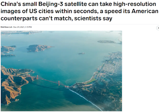
Mỹ không theo kịp Trung Quốc rồi
Vệ tinh Beijing-3 của Trung Quốc chụp ảnh độ phân giải cao thành phố Mỹ...
-----
The commercial (thương mại) Beijing-3 satellite (vệ tinh), launched by China in June, conducted (tiến hành) an in-depth (chiều sâu) scan of a 1,470 square-mile area in the San Francisco Bay. The satellite captured the area within 42 seconds.
Beijing-3 has a unique (độc đáo) advantage up its sleeve: It can pitch and yaw at up to 10 degrees per second while not compromising image quality as it orbits the Earth.
Normally, satellite cameras have to be kept still when they take high-definition images, and thus can only observe straight strips of land as they orbit above the area. So they sometimes have to fly over a region multiple times to scan the whole area or work in tandem with (song song với) other satellites.
The Beijing-3's maneuverability means it only needs a single sweep to observe entire regions, such as the 3,915 mile Yangtze River, the longest river in Asia, which winds from China's east coast to the western Tibetan plateau,
Tags: china


Post a Comment